Magellan
MAP410 GPS
The
MAP410 allows up to 20 routes with 30 reversible legs. Within
those routes you can save up to 500 waypoints or landmarks.
That's a whole lot for most of us. What's a waypoint? Say you're
at you are out and find a killer rock-ledge that you want to
bring your buddies back to on your next run. Simply hold down
the ENTER/MARK button and save your waypoint. The waypoint
is nothing more than a saved Latitude/Longitude point. You can
name the waypoint anything you like and you can even type in
a short note about it, like “great rock ledge.”
The
MAP410 has some other interesting features, like:
- SUN/MOON:
This will tell you the sunrise and sunset times of day
- FISH/HUNT:
Tells you the approximate best times for fishing and hunting
the area based on the sun/moon data. It lists Excellent
From/To and Good From/To times.
- TEMPERATURE:
The MAP410 has a thermometer built in and can read C or F.
- ALARMS:
There are several useful alarms, including arrival, cross
track error, proximity to waypoints, GPS (poor reception),
and anchor. These warn you when you are close to
waypoints, destinations, etc. The anchor is nice if you are
using this in a marine setting. You set the alarm which will
go off if you drift more than 100ft from your anchor point,
for example.
You can use
the MAP410 in conjuntion with your PC or laptop to send data to
mapping software from various companies to help you track on a
larger, colored screen. You can also download the data for archiving
and future use.
MAPSEND
Magellan puts
out a software application called MapSend. In order to use it,
you will need a special data cable which plugs in the back of
the unit and goes to your PC using a serial cable.
The MapSend
CD contains 250,000 uploadable Points of Interest (POI), which
include campgrounds, golf courses, museums, nautical navaids and
more. By using the software, you can select what sort of data
you want to add into your MAP410.
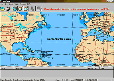
The
MapSend software loads very easily onto your PC. Simply plug your
MAP410 and cable into the serial port, insert the MapSend CD and
follow the instructions on your screen. There insn't much to using
it, really. The software opens up to a world view screen, seen
above. You can click around the world and use the magnifying glass
buttons to zoom in to your area of choice.
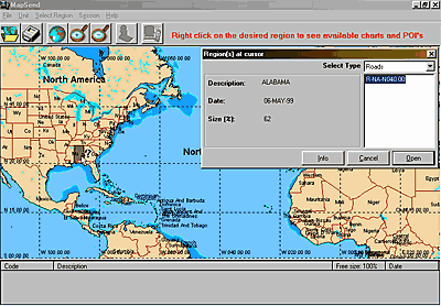
Once you find the area you want, right clicking on it brings up
a pop-up screen where you can choose the sort of data you want.
Roads and POI come with the package and you can load them at will.
However, if you want Marine or Superlake information, you need
to call and get unlocking codes and pay an additional fee.
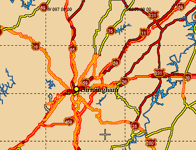
Once
you have selected what you want, you can also zoom in and see
an overview of the area. This is not a complete road map by any
means. This is about as much detail as we could get in the Birmingham
area. In other words, don't count on MapSend to be your PC mapping
software.
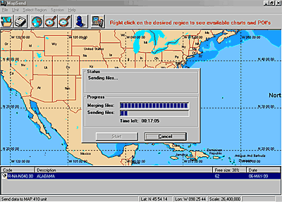
Finally,
download the information into your MAP410. This took us 17 minutes
to download Road and POI data. Once it is finished you can turn
your MAP410 back on and the data will be active. During GPS use,
you can turn the data on and off at will to unclutter your screen.
This data is available through displays and the menus within the
MAP410 for you to use during your journey.
MORE
--->>>
©
2000 Rockcrawler. All Rights Reserved
|