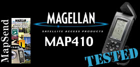
Magellan
MAP410 GPS
 If
you are in the market for a Global Positioning System (GPS)
now is a great time to do it. Last May, the US Government relieved
restrictions on GPS accuracy. Overnight, GPS's became more accurate,
and can now locate accurately within a tennis court. If
you are in the market for a Global Positioning System (GPS)
now is a great time to do it. Last May, the US Government relieved
restrictions on GPS accuracy. Overnight, GPS's became more accurate,
and can now locate accurately within a tennis court.
We
wanted to test out Magellan's
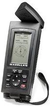
new MAP410 and got our hands on a test unit. The MAP410 costs
around $350 and is in what we would consider to be the higher
end of consumer GPS units. The MAP410 has an incredibly large
set of features packed into it's 6.32 x 2.5 x 1.4" frame.
Running
on either the included 4 AA batteries or an optional 12volt
car adapter/PC serial connector combo cable, the unit weighs
in under a pound with batteries on-board.
The
MAP410 comes with a nice case and strap and the on-board antenna
can flip up for better reception. We didn't notice a whole lot
of difference between it being up and down, however.
What
makes the MAP410 a “higher-end” unit for our purposes,
is that it comes from Magellan complete with road maps already
in its memory. Less-expensive units, like those found for $100-200
are every bit as accurate at tracking satellites, however, they
will give you nothing but Latitude and Longitude.
By
having maps onboard, the MAP410 will give you a reference to
where you are in relation to the roads you traveled to get to
the trailhead. Without the map feature, you would see nothing
but your indicator and the trail leading to it. We have found
this very useful in the backwoods. Sure, when we're out trailing,
we're obviously not on roads. However, if we're out and have
lost our bearings, we can zoom out on the map screen and find
the nearest road to help us find our way back.
In
addition, having road maps is wonderful on trips while you're
spending your time on the road. You can find a town or waypoint
to travel to and the MAP410 will estimate how long it will take
you to get there and tell you the straight-line distance. Keep
in mind, that distance is not necessarily accurate, because
roads turn and are not straight lines.
 The
MAP410 has 9 different navigation screen modes. You can select
to have just a couple or all of them active. We found that using
only a couple was more than adequate for us. The
MAP410 has 9 different navigation screen modes. You can select
to have just a couple or all of them active. We found that using
only a couple was more than adequate for us.
- POSITION:
Displays the coordinates of your last computed position and
basic navigation data. You can see Elevation, Date, Current
Speed, Compass, Coordinates, Time, Estimated Position Error,
Distance Traveled, and Course. You can also view
a secondary coordinate system from this screen.
- NAV1/NAV2:
Displays your destination along with four selectible navigation
measurements and a graphical compass.
- COMPASS:
Displays four customizable navigation fields, as well as a round,
traditional-style compass. In addition, there is also a Sun
Icon, Moon Icon, and Destination Icon, as well as a Course Deviation
Indicator.
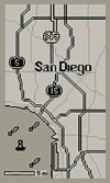
- MAP:
This is our favorite screen and packs the most information.
Obviously, this shows a map of your location. You can zoom in
and out using the buttons on the unit. You can also select up
to four different pieces of information to be displayed at the
bottom of the screen, such as Bearing, Distance, etc.. There
is an arrow which shows your location and aims either toward
North or toward the direction your are moving, depending on
your preference. You can also select at what zoom level cities
and roads show up on the map, as to reduce clutter on-screen.
There is also a really nice line and dot setup that shows your
direction of travel and approximate location one minute from
now.
- ROAD:
Displays four customizable navigation fields at the top of the
screen and a simulated road at the bottom. you show up as an
arrow on the road and the road moves and shifts depending on
whether or not you stay on-course. If you get far enough off-course,
and arrow will point you in the direction you will need to turn
to get back on. This is useful if you are trying to locate a
specific waypoint and do not need map data.
- SPEED:
This is a fun screen. You get a simulated speedometer, odomoter,
and trip odometer, as well as numerical bearing, course, speed
over ground, and course over ground. The speedometer also has
an average speed indicator. Though it's a lot of fun to watch,
you probably won't use this a whole lot.
- TIME:
Displays current time, estimated time enroute (ETE), time of
arrival and elapsed time. This could be useful if you were,
for example, running a rally, but otherwise, you may want to
leave this one out.
- SAT
STATUS: This is the default opening screen, which tells
you whether you have 2D or 3D (includes Altitude) navigation,
satellite positions and signal strengths, battery life indicator,
temperature (C or F), and North indicator. When you first turn
on the unit, you will go here. You will need to wait while the
MAP410 acquires satellites. You will not have map functionability
until the satellites are being tracked.
MORE
--->>>
| SOURCE |
Magellan
www.magellangps.com
471 El Camino Real
Santa Clara, CA 95050-4300
Phone: (408) 615-5100 |
©
2000 Rockcrawler. All Rights Reserved
|
|